2010 Summer Vacation Journal
Day 1, Friday, 28 May 2010. Got a late start, had to go by Dodge dealership to pick up a part I'd ordered. It had just come in so we were on the road by about 9:00 am. It was a high mileage day, 458 miles, just to get out of familiar territory. We had a good lunch at Fox's Pizza and a refreshment stop at Dairy Queen. We managed to hit Birmingham just in time for 5:00 pm rush hour, and a major thunderstorm. It took a long time just to get through town. We traveled in Florida, Georgia, and Alabama, spending the night in Tanner, AL. with a light dinner in the camper. The campground, Swan Creek, is more of a trailer park with a few spaces for transients. They advised us that there is a storm shelter and we are to head for it if we hear a siren. This is tornado country and they are prepared. (N34.70418, W86.95320) Photos
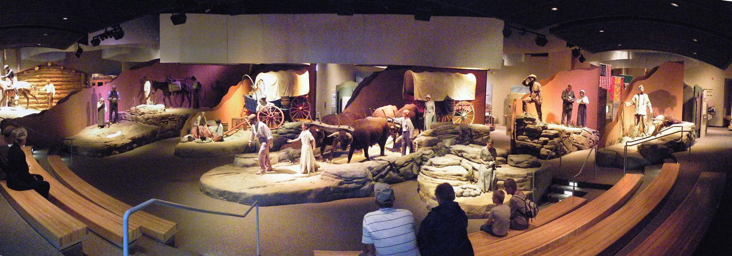
Day 2, Saturday, 29 May 2010. Woke up early and realized we'd gained an hour by entering the Central Time Zone. Got a quick departure and put on a few miles before stopping at a Shoney's for breakfast. Mason enjoyed the variety on the buffet. We made good time and a lot of miles, 433, because the weather was good and traffic was light. We barely slowed down to pass through Nashville. We stopped at a rest area in Illinois for a picnic lunch then continued on to St. Louis. We found on street parking right along the Mississippi River and visited the Jefferson National Expansion Memorial, better known at the Gateway to the West Arch. Mason enjoyed the river, the arch, and the museum. The Museum was packed but Mason really got into it. A ranger gave us a talk and let Mason try on some of the clothes that would have been worn on the Lewis and Clark expedition. Mason also took a lot of pictures. We continued on to the Sundermier RV Park in St. Charles, MO. He was disappointed that the campground didn't have a pool, but he continued watching the videos we brought to keep him busy on the long drives. It is neat to be driving along and suddenly hear a burst of laughter from the back seat. Apparently he is enjoying the videos. (N38.79839, W90.47282) Bruce's Photos Mason's Photos
Day 3, Sunday, 30 May 2010. Again up and out early for a long day's drive, 566 miles. Stopped for breakfast at Denny's, lunch at a rest area in Iowa, two fuel stops, stopped at a rest area/Welcome Station in South Dakota, then an afternoon snack at a truck stop near Sioux Falls, SD. Arrived at the Red Barn RV Park in Tea, SD about 5:30. While not as fancy as last night's campground, they have a pool, rec hall, and a lot of friendly people. Mason and Sandy finally got to take their first swim of the trip. The campground is an old prarie homestead with some of the old stuff remaining. The bath house is an old farm house with a storm cellar, and there is an old windmill style water pump. (N43.44521, W96.80490)
Photos
Day 4, Monday, 31 May 2010, Memorial Day. Leisurely start with stroll around campground and breakfast in camper. Dumped tanks. Drove to Chamberlain, SD and visited the Lakota Museum at the St Joseph's Indian School on the Missouri River. The museum was interesting, but didn't allow cameras inside. That is to protect the interest of the many artists on display. We had lunch at Casey's Cafe, home of the "Perfect Cheeseburger", overlooking the Missouri River, which had been dammed to form a small lake at this point. From there we drove into the Badlands National Park. This is an area of the plains that had been eroded by rivers and rain to form an area of rugged rock peaks and canyons, most below the level of the surrounding prarie. It was once known as a good place for an outlaw to hide out since it was almost impossible to search all of its nooks and crannys. We got out and climbed on the rock which gave us a real "hands on" experience. The visitors center had interesting displays of the geology and history of the area, which was even avoided by the Indians. We followed the scenic road through the park, stopping to watch the inhabitants of a small prairie dog town, to Wall, SD. We had considered touring the heavily advertised Wall Drugs store, but it turned out to be an overwhelming tourist trap, so we went on. We settled into the Mystery Mountain Resort in Rapid City, SD. There was time for Mason to go swimming, dinner in the camper, then we all played a round of minature golf. This was a relatively short 372 mile day. (N43.97451, W103.30823) Photos
Day 5, Tuesday, 1 June 2010. Another leisurely start for a short mileage day. We drove to Wal-Mart for a supply run, and to extinguish the hole being burned in Mason's pocket by the money he had earned being so pleasant and productive on the long driving days. He found some Star Wars Legos he didn't already have. Then we had breakfast buffet at Golden Corral and headed down to Mount Rushmore. The weather was good and he enjoyed the view. We took the hiking trail that makes a loop from the viewing area to under the noses of the statues. It gives a close up view and permits seeing the marks and debris from construction. The trail also leads to the sculptor's studio where there are models and molds used to get the measurements transfered to the mountain. There were also a short film, a museum, and of course a gift shop. Next we went to the nearby town of Keystone and stopped at the Big Thunder Gold Mine. Mason elected to pan for gold instead of taking the tour. (He seems to enjoy the involvement of being hands on.) He ended up spending as much time panning as he would have taking the tour, only giving in when the rain started. We then took route 16A south, which I contend is twistier that the Tail of the Dragon. There are 360 degree spiral turns with bridges and tunnels. Plus it is prettier country. The route took us through a portion of Custer State Park, were we saw some mountain goats (or sheep, it was hard to tell). We arrived at Beaver Lake Campground in Custer, SD, and were disappointed that the water slide was closed due to the rain and 50 degree temperature, but Mason was able to enjoy the heated pool. This was a short 78 mile day. (N43.73932, W103.65716) Bruce's Photos Mason's Photos
Day 6, Wednesday, 2 June 2010. Breakfast in the camper, then we headed out. We drove south through Wind Cave National Park, with stops to photograph bison and pronghorns, including one that walked slowly down the road in front of us. We went to the Mammoth Site in Hot Springs, SD, were we had a reservation for Mason to participate in a junior paleontologist dig. After the tour of the site, we joined the rest of the kids and they all got to play in the dirt, using appropriate tools and methods to uncover bone replicas buried in the dirt. Mason was excited at finding two bones, and filling more buckets of dirt than anyone else. We checked a list of restaurants and selected one that looked good. When we arrived there we realized that it is where Sandy and I ate on our first trip here in 2004. Again the food was excellent including the buffalo burgers. Returning to Wind Cave National Park, we took the cave tour. Mason was very excited, took lots, and lots, and lots of pictures. The ranger twice gave him special jobs to do to help the tour. On the way out we stopped for some photos of grazing mule deer and another herd of bison. Heading back to the same campsite in Custer, we stopped downtown for some shopping, including some more work books for Mason to keep him busy and allow him to "learn and earn" on the road. At the campground, the water slide was open, so he ran himself to exhaustion while Sandy did laundry. This was a another short, 70 mile, driving day. (N43.73932, W103.65716)
click photo to enlarge
Day 7, Thursday, 3 June 2010. Breakfast in camper. Drove to Casper, WY. Stopped for a break at a city park in Lusk, WY. Very nice park with a historic log cabin that had been moved to the park from an early prairie homestead. On the way out of town we recognized the neighborhood. We had stayed at BJ's campground on our '08 trip. Continued to Casper, had a great lunch at Poor Boy's Steakhouse. Lunch was surved in a very elegant "pump room", but the food was resonable priced and very good. Continued to the Historic Trails Museum. We had also visited here in '08 and it was worth returning to. Mason had a good time, especially with the hands on exhibits. From there we went to a KOA in Casper. We didn't have reservations, but they had vacancies. They also have a great pool. It is indoors and heated, a real treat on these cool afternoons. We all swam then retired to the camper for dinner (leftovers from lunch). (N43.91384, W106.34145)
Day 8, Friday, 4 June 2010. Breakfast in camper, unhooked, dumped, continued west into Wyoming. Took a break at a rest area. They have pens for dog walks, so your dog can play off a leash. Continued to Riverton where we stopped at Wal-Mart for groceries and more Legos. Further west we stopped at another rest area for lunch. We watched some horses frolicking. We passed through the Wind River Indian Reservation, and crossed the winding Wind River several times. Checked into Wind River KOA in Dubois, WY, in a light drizzle after 192 miles. Our site backs up to the Wind River, which is rushing very fast. Enjoyed the indoor pool while Sandy did laundry. Back to camper for dinner. (N43.53139, W109.63573, elevation 6,941 feet, over a mile above sea level) Photos
Day 9, Saturday, 5 June 2010. Breakfast in camper. Still raining. Continued west. Stopped on a mountainside for snow play. Sandy and Mason sledded and threw snowballs. Mason made a snow angel. On to Grand Teton National Park. Toured the park through Jackson Hole, stopping for many photos of the incredible mountains. Stopped at the visitors center. Took a hike along the String Lake trail to a waterfall and outlet into the lake. Wandered around the park taking lots of pictures of scenery and wildlife. Checked into the Coulter Bay Village. Took a walk around the area after Sandy put in the laundry. Decided against eating in the restaurant after viewing the menu. Mason found a snow bank remaining from plowing the parking lot that he could play in. They have a very nice marina with boat tours of the lake, rental boats, and many large private boats. Mason played at the lake's edge while Sandy explored a trail. Back to the camper for dinner. Started raining again. (N43.90596, W110.64440, 6,834' msl) Bruce's Photos Mason's Photos
Day 10, Sunday, 6 June 2010. Breakfast in camper. Some last minute photos as we left Grand Teton NP and entered Yellowstone NP. Stopped at the West Thumb Geyser Basin for a short walk through the steam from the bubbling geothermal springs. Stopped at a trail head for some more snow play. Changed into dry clothes in the camper. Stopped at Kepler Cascades, a large waterfall with an overlook built over the river. Had lunch at Old Faithful Lodge, overlooking the geyser from our table. Minutes after finishing lunch we went outside to watch the geyser erupt. Explored more of Yellowstone. Took a walk at Midway Geyser Basin. The steam fogged our glasses so much we had to put them away for the walk. This walk included the largest hot spring in Yellowstone and a now geyser that no longer erupts but send a steady 4000 gallons of boiling water into the Firehole River every day. We took a short scenic road along the Firehole River to Firehole Falls, arriving just before a tour bus arrived and unloaded. Continuing out the West gate of the park we passed more wildlife, including a herd of bison roaming a crowded parking lot. We crossed into Montana just before leaving the park. Cutting across the corner of Montana, we entered into Idaho. We found an out of the way campground called Red Rock RV and Camping Park in Island Park, Idaho. It turns out the park is run by a couple who retired from BellSouth in Gainesville, FL.
More laundry. We have had steady rain since arriving in Dubois, WY last Friday.
(N44.60384, W111.41683, 6,579 msl) Bruce's Photos Mason's Photos
Day 11, Monday, 7 June 2010. Breakfast in camper, still raining. Continued west. Stopped for a stretch break at Hell's Half Acre National Monument, an area of lava outflow from a fissure in the Earth. Passed through the Idaho National Labratories, a highly secured federal complex. Lunch the Golden West Cafe in Arco, ID, home of the first nuclear power generating station and "The First City in the World to be Lit by Atomic Power". Stopped downtown for a display explaining the cities history. The INL area was the labratory which produced the first nuclear power plant, providing electricity to the city. It also developed the first nuclear naval propulsion reactor and was used to train the crews of atomic submarines. Today it is used as a waste storage and disposal area, with research into safer methods of decommissioning nuclear waste. The display includes the "sail" of a nuclear submarine, SSN 666, the USS Hawkbill. I photographed all the exhibits to read more thoroughly later.
Approached Craters of the Moon National Monument just as the rain ceased. Facinating place, a thermal upheaveal littered the landscape with lava flows. There is a seven mile loop road with several stops. We climbed a 130 foot lava cone, with a great view of the surrounding countryside. It was more difficult than we had expected, probably because the base is about a mile above sea level to begin with. We then hiked a trail that led to four different caves, which are open for exploration. Unlike Wind Cave, these do not have developed trails, lights, or guides. It is up to the tourists to provide there own flashlights and to scramble over the rocks to explore the caves. Mason loved it!
Since the rain had stopped, we decided this would be a good night for wilderness camping. We got a map and directions from a ranger station and drove up into the Sawtooth Mountains National Forest. We found a nice mountainside campsite and set up for the night. Since there was no level ground, I used the camper's jacks to level us out. Unfortunately I over extended one of the jacks and broke a turnbuckle. We'll have to continue on without it until we can find a replacement. The campsite was by a creek and had a fire pit. We started a fire and Mason played all over the place. He decided to try his hand at building an emergency shelter with the materials at hand. He did a really good job. We cooked dinner over the fire and ate outside at the picnic table. We went to bed expecting a cold night, setting the gas furnace to come on if it got too cold. Nothing like roughing it is central heated comfort. (N43.54310, W114.81937, 5,927' msl) Photos
Day 12, Tuesday, 8 June 2010. Woke up to 32 degrees outside. The heater had done it's job and we were comfortable. Hot cocoa and biscuits from the oven helped take off the remaining chill in the camper. Struck camp and continued on a loop through the forest, stopping for wildlife, a hot spring, and a beaver dam. Stopped at a country store in Fairfield for some groceries. Today is to be a travel day. Stopped for some scenic photos then drove on. Entered into Oregon, had lunch at a Sizzler restaurant in Ontario, OR. Crossed the 45th parallel, which is half way between the equator and the north pole. Continued to the Hatrock Campground, next to Hatrock State Park, Hermiston, OR. Office was closed (at 5:00 pm!) so we made ourselves at home and Mason swam in the pool, but it was cold. Mason tried out the balsa airplane he'd bought and we ate dinner outside again. Started to rain, went inside to bed. (N45.91028, W119.17025) Photos
Day 13, Wednesday, 9 June 2010. There was a woman in the office early, so we could check out without waiting for the scheduled 9:00 am opening. On the road by 8:00 am. Driving day, drove much of the day through the Columbia River Gorge. It was breathtaking. Entered Washington. Stopped for lunch at the Country Cafe in Ridgefield, WA. Crossed
back into Oregon. Stopped for fuel and groceries in Astoria, OR. Then back into Washington on the western-most bridge over the Columbia River. Continued to Cape Disappointment State Park. Met Genny, Loren, and Jacob there. We got to move our site to be closer to them. Walked on the beach, exploring small caves and climbing on driftwook and large rocks. Mason got his feet wet in the Pacific Ocean. Saw a seal pup resting on the beach. Dinner over their campfire. Played Uno under a tarp in the rain. Retired to our camper and slept with the heat on. (N46.29026, W124.07477) Photos
Day 14, Thursday, 10 June 2010. Slept late. Breakfast in camper, explored some more of the beach. Met with Gen, Loren, and Jacob. Rode in their car to explore the park. Hiked to the top of McKenzie Head. Toured the Lewis and Clark Interpretive Center. Back to camp for lunch. Took our truck (more seats, with camper attached) to explore more. Visited the North Head light house. Mason and I climbed to the top. He impressed the guide with his knowledge and math skills. Drove to Waikaki Beach and explored some more. Climbed with Mason to the top of a rock bluff about 30 feet over the water. It somehow reminded me that we missed the Explorers trip to the Gainesville Rock Gym.
Drove in the truck into Long Beach, WA. Had dinner at Castaways Seafood Grill. Had a great dinner, and dessert, and a great time. Drove back to camp for another good night's sleep. This is the midpoint of our journey, and as far west and north as we are going. Tomorrow we start our return toward home. (N46.29026, W124.07477) Photos
Day 15, Friday, 11 June 2010. Broke camp and dumped the tanks. Bid good-bye to the kids and headed out. Returned to Astoria, OR and visited the Columbia River Maritime Museum. It was one of the best maritime museums I've ever visited. There were lots of hands-on exhibits, including lighthouses, Coast Guard Rescues, river fishing, war ships, including a destroyer bridge, etc. Headed south on US101 along the Oregon coast. Stopped for lunch at Gearheart Junction Cafe in Gearheart, OR, just outside of Seaside. Stopped at a roadside stand for fresh cherries. Continued to Newport, OR for a stop at McDonalds. We had ice cream and bought Mason a chicken nugget meal to have for dinner tonight. Checked into the Sea Perch RV Resort in Yachata, OR. This campground is right on the beach. I took Mason and Khloe down to the beach where they both played. Mason collected driftwood and rocks. Sandy started laundry then took over while I took a shower. The campground has a very nice clubhouse with the laundry, large family style bathrooms with showers, a computer room, a kitchen, a game room with a pool table and table soccer game, and a fancy lounge with a wall mounted flat screen TV. Very swanky! Sandy took Mason to the shower and finished the laundry, then returned to the camper and prepared dinner. Took pictures of sunset, played some catch with Mason. Worked on photos while Sandy and Mason played cards. To bed. (N44.23019, W124.10978) PHOTOS
Day 16, Saturday, 12 June 2010. Played pool and foosball in clubhouse with Mason. Breakfast in camper, late stroll to beach. Hit the road. Drove south to Sea Lion Caves. Went down into the cave to see the sea lions. The greatest impression made on Mason was the smell, he was very happy to return to the surface. Watched the sea lions on the rocks and in the water, as well as a deer grazing on the slope of the cliff. Continued south, stopped for lunch at the Crazy Norwegian in Port Orford, OR. Continued south, with many stops to enjoy the view, into California. Had to give up the remaining cherries we'd bought in Oregon to the California border inspectors. Drove through the Redwood National and State Parks along the coast. Took the scenic route and stopped at the "Old Tree". Hiked a couple of the trails in that area. Continued south to Trinidad and camped at The Emerald Forest. This is an old campground nestled in the woods with many giant redwoods on the property. A little muddy, but nice. Tried to cook over a campfire but the wood we bought just burned up without leaving any coals to cook over. Fortunately we have microwave and toaster ovens so the meal was still good. (N41.07305, W124.14217) PHOTOS
Day 17, Sunday, 13 June 2010. Travel day. We left early and continued south on US101. It is very scenic with lots of twistys crossing over the mountains. Stopped at JC Cafe in Junction City for breakfast. Got onto I-5 to Stockton, stopping at a rest area for lunch. Then onto CA120 east. Stopped at a Wal-Mart for supplies, (groceries, camera batteries, and more Legos). The route from Copperopolis over another mountain pass looks so familiar, we much have taken it on the last trip in the opposite direction. Pulled into Yosemite Pines Campground in Groveland, CA. The office is closed so we dropped a form in the slot and took a site. Sandy and Mason swam in the pool, which I am told was very cold. That didn't deter Mason who stayed in a half hour after everyone else got out and the sun was setting. Dinner in the camper. The shower stall I got had no water pressure so I took a very short shower under a trickle of water. (N37.82528, W120.19624) PHOTOS
Day 18, Monday, 14 June 2010. Checked out of the campground and proceeded to Yosemite National Park. We drove the loop throught Yosemite Village to get photos of the waterfalls and the famous rocks: El Capitain and Half Dome. Through binoculars we could see climbers on both. We then returned to the main road and traveled up over Tioga Pass. Stopped several times for snow play, rock climbing, and taking in the natural beauty of the mountains and waterfalls. One area was the same place we stopped with Heather and her girls, but we played on the opposite side of the road. What was a lake two years ago was a snow field today. Left the park and stopped in Lee Vining, CA for fuel and dumped the holding tanks. Also got some photos of Mono Lake. Continued east, entering Nevada, and stopping at Tonopah, NV. We camped in the parking lot of a casino, with complete hook ups and laundry. Sandy did laundry and we all ate dinner in the casino restaurant. (N38.05765, W117.21911) PHOTOS
Day 19, Tuesday, 15 June 2010. Leisurely start since it shouldn't be too long a day. Drove the Extraterrestrial Highway with a stop in Rachel, NV for photos of the UFO and ET gizmos. Stopped to examine some cactus along the way. Continued to Caliente, NV for fuel and lunch. Ate at the Branding Iron Restaurant. Met a couple on a motorcycle trip and got a photo of her "no coast choppers" shirt. Continued east, realized that we'd left the restaurant without paying. Turned around and backtracked for about 10 miles. The waitress was happy to see me. Back on the road. Passed into Utah. Stopped for fuel and groceries in Cedar City, UT. Stopped just outside of Zion National Park for a propane refill. The gauge on the tank is very pessimistic, but it is better to be safe than sorry since we will be without hook ups for several days. Checked into the Watchman Campground in the park. There is road construction which will make us change out exit plans, but it might be to the better considering how Mason and Sandy do on winding roads. The additional mileage isn't too great. Mason put on his bathing suit and played in the Virgin River nearby. Sandy cooked dinner in the camper and we ate out on the picnic table. We couldn't find firewood since the host's sites are vacant. (N37.19500, W112.98957) PHOTOS
Day 20, Wednesday, 16 June 2010. Leisurely start, breakfast in camper. Packed backpacks and filled water bottles. Rode free shuttle up Zion Canyon. The road is now closed to private vehicles except guests at Zion Lodge. This reduces congestion, pollution, and parking problems. Stopped at Zion Lodge stop and hiked to the Middle Emerald Pool. Hiked back on the Kayenta trail which brought us out at the Grotto stop. Refilled water bottles and had a snack. Back on the shuttle up to the Big Bend stop. Got off for photos and back on the next shuttle. Rode to the top at the Temple of Sinawava and walked along the river walk. We could see into the narrows of the canyon but Mason was too tired to walk any farther. Took the shuttle back down to the Weeping Rock trail. Hiked up to the lookout that is under the trickling waterfall. Back down and on the shuttle. Off at the Lodge again for some ice cream cones. Then back on the shuttle to the museum. Toured the museum and watched the 22 minute film. Back to the visitors center on the shuttle. Went through the visitors center and gift show, then walked back to the camper. Mason and Sandy put on bathing suits and went down to the river while I scouted for firewood. I learned that you have to go into town, Springdale, to buy wood. I put on my suit and went down to the river. It was too cold to go in more than knee deep, although there were people swimming and tubing in the river. Back to the camper for dinner. Walked into Springdale, it is a short walk up the the visitors center then across the bridge into town. Bought firewood and marshmallows and walked back to the camper. It has been very windy all day and is still too windy to start a fire. We expect the winds to die down once the sun has left the canyon. Took a lot of pictures today because everytime I looked up there was another spectacular vista. Winds died as expected, built fire and enjoyed hot dogs and marshmallows.
PHOTOS More Photos
Day 21, Thursday, 17 June 2010, Leisurely start. Left Zion and drove into Rockville. The GPS showed a shortcut not shown on the state highway map, so we looked for it. Missed the turn but stopped at the Post Office to mail some postcards then made a U-turn. We found an unmarked side street and took it. The GPS seemed to be happy. Across a narrow bridge and onto a rough dirt road. After a mile or so we saw another car turning around and heading back to town. We decided to venture on. Before long we in 4-wheel drive and climbing a very steep and rough hill. Once on top the road smoothed out and the views were incredible. We continued on and soon emerged on the highway we had originally planned to take, but we had saved over 60 miles. Continuing into Arizona we saw signs for Pipe Springs National Monument. We stopped and took the tour. It is a joint venture of the National Park Service and the Paiute Indian Nation. It was originally a Mormon pioneer site and had a very interesting history. The ranger mentioned that their traffic has increased tremendously since the road through Zion closed and traffic is now detouring past his park. We stopped for fuel and lunch at Jacob Lake, AZ and arrived at the North Rim of the Grand Canyon. On the way in we noticed a lot of fire damage in the forest. We checked in and were assigned site 3. We drove to the site and found a tent already set up there, with a post tag showing the Martin family is on site T-03 until tomorrow. We went back to the check in ranger and we decided that the Martins were on the wrong site, but rather than track them down and have them move, he did have one unsold site from a cancelled reservation, so we moved onto site 31 for one night. We drove up to the Lodge to check on ranger programs then returned to the campsite. Sandy went off to do laundry while Mason laid a fire. Someone removed her laundry before it was done, so she had to try to fix it. A young couple approached us asking in very broken English for a favor. They had reservations to hike the canyon train tomorrow, but didn't have camping reservations for tonight. The ranger recommended they find someone in a camper who would allow them to put up their tent in exchange for paying half the camping fee. We not only invited them to stay but we also didn't accept their share of the fee (we already had a great discount) and invited them to share our food and fire. The woman, Katarina, was from Slovakia, and the man, Claus, was from Germany. They had flown into San Francisco and rented a Ford Mustang convertable for their trip. We had hot dogs and marshmallows over the fire. I took a vending machine shower, paying $1.50 for 5-7 minutes of high pressure water in a metal booth, it reminds me of a automatic car wash. Went to bed with a considerable lean to the camper from the unlevel pavement. (N36.20922, W112.05873) PHOTOS
Day 22, Friday, 18 June 2010. Slept late. Sandy went up and finished the laundry. Breakfast at the picnic table. Drove up to the Lodge and checked at the visitors center. The program we wanted had been cancelled because the knowledgeable ranger was not available. It was the program about the early inhabitants, including exploring some archeological ruins and have a weapons demonstration including the atlatl (spear throwing stick). We hiked some of the trails around the lodge. Sandy signed Mason and herself up for a mule ride. We enjoyed a talk about fire in the area. The ranger mentioned the fire we noticed coming in and said it happened in July of 2006. We checked our journal and discovered we had been here with Morgan in June of 2006, just before the fire. He also mentioned a "candleabra tree". It is a Ponderosa pine that has hit by lightning so many times that it has many trunks coming out on one base. He told us were it was on the nature trail. We hiked the Transect trail till it met the nature trail then took the nature trail. We realized that we were looking for a single tree in a huge forest. Just as I spotted the end of the trail, I also spotted the tree, and the ranger walk along the road. He stopped and told us again about the tree while I took pictures. Sandy and Mason went on ahead as I took a few more photos, and tripped, skinning up my leg. We has lunch in the camper in the visitor center's parking lot. We went back to the lodge and Sandy and Mason waited for the bus to the corral. I drove ahead to the corral and got pictures of them arriving and mounting up. I followed the company photographer to her favorite scenic spot on the trail and took more photos as the group passed. While they were riding, I drove out on the point road to the trailhead, then continued on a few miles more. I found an intersection of the Arizona trail and got some pictures of their signs. Back to the visitors center. Met with Sandy and Mason and had some ice cream. Then we drove back to the campground, this time into site 3, and Sandy cooked dinner which we ate on the picnic table. Mason set and lighted the fire for tonight and did a great job. We had s'mores before bed. 13 miles for the day. (N36.200956, W112.06055) PHOTOS
Day 23, Saturday, 19 June 2010. Left Grand Canyon, stopping to look at the fire damage that had happened just a month after we had been there with Morgan. Stopped for breakfast at Jacob Lake Inn again. Even had the same waiter, Mike, a Mormon college freshman from Utah. As we entered the restaurant we noticed the number of rental cars, rental campers, and rental motorcycles in the parking lot. We commented on the availablity of anything needed for a trip for rent. When we left we commented that we had both noticed a couple and concluded that she was also probably a rental. Avoided some questionable GPS suggested detours and stayed on the MapQuest route. It only amounted to a few miles difference but we avoided some roads that the state highway map showed as incomplete. The entire trip was through Indian Reservation, including Navajo and Hopi. It reminded us of some of the poor sections we had seen in Mexico 40 years ago, including entire villages without electricity. Crossed over the Colorado River above the canyon. Stopped to walk the original Navajo Bridge, and watch a rafting trip come down the river. Drove to Chinle, AZ, where they have horses and cattle wandering the streets as part of open range. Checked into the Navajo run Thunderbird Lodge in the Canyon DeChelly National Monument. We are taking a relaxing afternoon for a break. We have an air conditioned motel room with Cartoon Network on TV for Mason. Khloe is staying in her own "kennel" in the parking lot. Had dinner in the cafeteria and retired to our room to relax, including luxuriating in the shower. (N36.14671, W109.53934) PHOTOS
Day 24, Sunday, 20 June 2010. Up promptly in the morning. Breakfast in the Lodge cafeteria. Packed up and moved to the Holiday Inn parking lot to meet our tour guide. Our guide is a Navajo woman named Irene. We got into her Jeep and she took us for a tour of the canyon floor. No one is permitted on the canyon floor without a National Park permit and a native guide. Not only was the tour fascinating, including cliff dwellings, petroglyphs, etc. but Irene was also very interesting. She had grown up in the canyon and had herded sheep as a child. She also collected firewood and played among the ruins. She added to the tour by telling us about her own life. After the tour we headed out on the road again. Entered into New Mexico and stopped at Pizza Hut in Gallup for lunch. Continued on to Acoma, where we got a campsite in a gravel campground attached to the Sky City Casino. We parked in a site and went into the casino to register. We then swam in the pool at the casino, and Sandy did laundry at the Travel Center (gas station) across the street. The facilities are overrated in the Campground Directory, since all facilities, inclulding bathrooms, are about a quarter mile walk from the campground. The whole scene looked very familiar and then I saw a sign I recognized from our previous trip. We had stopped for fuel there two years ago. Retired to the camper for the night. (N35.07972, W107.55715) PHOTOS
Day 25, Monday, 21 June 2010. Breakfast in camper, stopped for fuel at Sky City travel center. Hit the road across New Mexico. Stopped for several historical markers, including Trinity Site, the location of the first ever nuclear bomb explosion. When we crossed the Rio Grande river, Mason asked if that put us in Mexico. Drove to Alamogordo, NM. We stopped so Sandy could buy a chili pepper wreath and had a Mexican lunch at Casa de Suenos. Mason selected the buffet because the kid's taco plate had only one taco. He ate three from the buffet. I managed to get a plain cheeseburger, since everything on the menu was heavy with peppers. Drove to White Sands National Monument, which is in the White Sands Missile Testing Area. Sometimes the Monument is closed due to missile launches. We watched a short video and drove out to the dunes. It was fascinating, and Mason and Sandy got to sled down the dunes. We didn't stay too long, since the temperature was 104 degrees. Drove back into Alamogordo for groceries and fuel and headed east. Within miles we were up in the mountains and the termperature had dropped. We found the Deer Springs RV Park in Mayhill, NM where we camped. The temperature was 75 when we got into our site. Mason played by the creek since there was no pool. He asked me to have a poo race with him, which I wasn't so sure about. It turned out he wanted to race Pooh sticks in the creek. (N32.88073, W105.48718) PHOTOS
Day 26, Tuesday, 22 June 2010. Breakfast in camper. Today is a day to make mileage. We headed out and drove into Texas. Stopped at Idalou, TX, just east of Lubbock for fuel. Sandy notice that the air conditioner seemed to be dripping a lot of water, but it is a very hot day. Got a few miles down the road and the "check gauges" lamp lit. We were badly overheated. Pulled into the only available place, which was the parking lot of the Crossroads Restaurant and parked under a cottonwood tree. We had lunch there while waiting for the engine to cool. We tried putting in water, but it immediately ran out on the ground. I couldn't see the leak but it was in the vicinity of the lower radiator hose. Called our road service and they dispatched a wrecker. While waiting, Mason played with a chili pepper. He then climbed the cottonwood tree and scratched his leg. He rubbed the scratch and it began hurting badly. This made him cry, so he rubbed his eyes. Of course his eyes starting burning, and we were unable to take him anywhere for help. Sandy washed out his eyes with water just as the wreaker came. The driver artfully loaded the truck with the camper onto the wreaker and we all piled into his cab. It was tight, Mason was freaking out, but the driver was very good natured, and sympathetic, about it all. Mason finally started to feel better and calmed down. The driver took us to the Firestone dealer that the road service had selected, but they said they couldn't help. He called around and found another shop for us to go to. The wreaker driver took us to Complete Care Care, a NAPA service shop, just two blocks away. They looked at it immediately and determined that the water pump had gone out. They ordered a new from from their warehouse and began taking out the old one. The new one arrived quickly, but by then it was closing time. We were still parked outside, so the shop manager strung an electrical extension cord from the shop to power the camper and allowed us to came the night right there. He also recommended several restaurants and offered to loan us his personal car if we needed it. We declined since everything we needed was within walking distance. We walked about two blocks to the Market Street market and had a great dinner from their deli. They even have a dining area in the grocery store. We then walked back to the camper and got Khole. We walked back to Sonic Drive In and discovered that they had a small park behind where they were putting on live music. We bought desserts and sat with the crowd enjoying the music. We met a local couple and chatted for a while. Finally we returned to the camper for the night. We now have new memories of Lubbock Texas. Even with the engine trouble we made 250 miles for the day. (N33.54939, W101.89279) PHOTOS
Day 27, Wednesday, 23 June 2010. We got up and dressed before the the shop opened. Had breakfast in the camper and Sandy took Mason back to Sonic. Since the truck was already being worked on, I had the serpentine belt replaced and the oil changed while it was there. They finished quickly and we were back on the road about 11:00 am. Passed through several small Texas towns looking for a lunch stop. After passing up a liquor store disquised as a restaurant, we found the Rockin' Grill. The steaks were excellent, the service very good, and the atmosphere outstanding. There were music decorations on the wall and flat screen TV's playing an Eagles concert video. We had seen many towns with decorated statues of animals, including Buffalo, horses, etc., but this town had old tractors throughout the town decorated in various ways. Stopped at Dairy Queen for dessert and continued on to the Shady Lake RV Park in Sulphur Spring, Texas. We arrived about dark, but Mason and Sandy still got a swim in the pool. Despite the late start, we managed to make 387 miles for the day. (N33.09507, W95.65074) PHOTOS
Day 28, Thursday, 24 June 2010. Got an early start to try to make up time. We immediately encountered very heavy rain, highway construction, and very heavy traffic. Mostly interstate highways today. Entered Louisiana. Stopped at Arby's for lunch in Minden, LA. Stopped at Baskin Robbins for dessert. To Bonita Lakes RV Park in Meridian, MS. We are early enough for all to get a swim. Dinner in the camper, finishing the left over steaks. Mason got to swim some more. Made 444 miles today. (N32.36748, W88.64961) PHOTOS
Day 29, Friday, 25 June 2010. Early start to make time. Entered Alabama. Drove down to Mobile, AL, but decided to skip the tour of the USS Alabama since Mason is anxious to get home. Entered Florida and stopped at Welcome Station for short break. Stopped for lunch at Fazoli's in Pensacola. Stopped for Dairy Queen in Greenville. On to McAlpin. Of course Mason's family was delighted to see him. Left Mason at his home and returned home. Made 472 miles today and 7,507 for entire trip. PHOTOS
We are all happy to be safely home after such an adventure.